Okay, let’s cut the fluff. You know what’s actually wild? Most construction companies still rely on old-school checklists, “walk-arounds,” and half-baked WhatsApp photos to check up on construction progress.
Meanwhile, the rest of the world is flying robots over job sites, capturing a bird’s-eye view, and turning thousands of photos into crystal-clear, 3D maps.
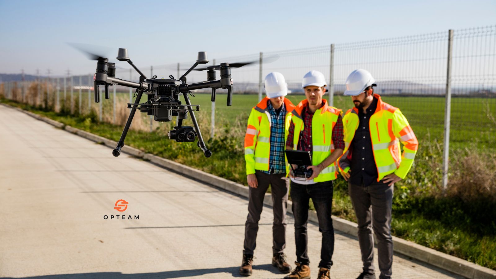
Ever had that moment where you’re sure the crew poured the concrete… until you show up and see a muddy mess instead? Yeah, we’ve all been there. But now, drones are out here making “trust, but verify” a whole lot easier. With smart tech like AI image analysis and instant cloud uploads, progress tracking has leveled up—way up.
Companies are already saving weeks of guesswork and loads of cash by switching to drone-powered site surveys, and the numbers prove it, project managers using drones have reported up to 50% time savings and far fewer disputes (check out these stats from Deloitte’s latest report). The future of construction progress tracking isn’t just coming, it’s basically hovering right above your hard hat.
Let’s dig into why drones construction progress tracking is flipping the script, and how you can get in on the action before everyone else does.
What is Drones Construction Progress Tracking?
Drones construction progress tracking is the use of unmanned aerial vehicles (drones) to monitor and document the development of a construction project from above. By flying drones over a site at regular intervals, teams can capture high-resolution images, videos, and even 3D models, providing a clear and up-to-date overview of the entire project. This approach gives stakeholders a reliable way to see exactly what’s happening on-site without needing to be there in person.
With the data collected, specialized software stitches images together and creates visual reports, making it easy to compare progress over time, spot potential issues, and keep everyone on the same page. Drones save time, boost accuracy, and bring a new level of transparency to construction progress tracking—helping projects stay on track and making delays or problems harder to miss.
How it Works?
Drones construction progress tracking starts with planning scheduled drone flights over the construction site. The drone captures high-resolution images, videos, or 3D scans from multiple angles, providing a detailed visual record of the project at every stage. This aerial data gives project teams and stakeholders a comprehensive and up-to-date view of site progress, without relying solely on ground-level reports or manual site visits.
Here’s how the process typically works:
- Drones are flown over the site on a regular schedule (weekly, monthly, or as needed).
- They capture photos, videos, and sometimes 3D models of the entire area.
- The data is uploaded to specialized software that stitches images together and builds progress reports.
- Teams can compare current visuals to past reports or construction plans.
- Issues, delays, or deviations are easily spotted and addressed early.
By automating site documentation and offering a bird’s-eye view, drones make construction progress tracking faster, more accurate, and much easier to share. This helps keep everyone aligned, reduces the risk of surprises, and supports better decision-making throughout the project.
Benefits of Drones Construction Progress Tracking
Drones construction progress tracking brings a host of advantages to any project, changing how teams monitor, document, and communicate progress on site. Instead of relying on outdated or incomplete information, drones deliver real-time visuals and data, giving everyone a clear and reliable view of what’s happening.
Key benefits include:
- Faster data collection: Drones cover large areas quickly, capturing site-wide updates in minutes instead of hours.
- Improved accuracy: High-resolution aerial images and 3D models offer details that ground-level photos can miss.
- Better transparency: Easy-to-share visual reports keep clients, stakeholders, and teams in the loop.
- Early problem detection: Compare progress to plans and spot delays, safety hazards, or quality issues before they escalate.
- Reduced site visits: Stakeholders can review site progress remotely, saving time and travel costs.
- Enhanced documentation: Automated records create a clear audit trail for compliance, claims, or disputes.
Overall, drones make construction progress tracking smarter, faster, and more reliable—helping projects stay on schedule and under control.
Best Drones For Construction Progress Tracking
When it comes to construction progress tracking, not all drones are created equal. The best drones for the job combine high-quality cameras, long flight times, and smart features like automated flight paths and easy data integration. These drones help construction teams capture consistent, accurate site data with minimal hassle, making progress tracking smoother and more reliable.
Some of the top drones for construction progress tracking include:
- DJI Mavic 3 Enterprise: Compact, reliable, and equipped with a high-resolution camera, making it a favorite for detailed site mapping.
- DJI Phantom 4 RTK: Known for its precision and built-in RTK module for centimeter-level accuracy—great for surveying and modeling.
- DJI Matrice 300 RTK: A rugged, versatile drone that handles larger sites and tough conditions, with multiple payload options for advanced imaging.
- Parrot Anafi USA: Lightweight, user-friendly, and equipped with thermal and zoom cameras—ideal for smaller sites or quick inspections.
- senseFly eBee X: Fixed-wing design for covering very large areas in a single flight, popular for big infrastructure and land development projects.
Choosing the right drone depends on your project size, required data detail, and budget, but investing in a quality drone ensures you get the consistent, actionable site data you need to keep your construction projects on track.
What are the Problems with Drones in Construction?
While drones have transformed construction progress tracking, they aren’t without their challenges. Even with all the tech advantages, there are practical, legal, and operational hurdles that teams need to keep in mind before launching a drone on-site.
Common problems with drones in construction include:
- Regulatory restrictions: Drone use is heavily regulated in many countries—getting permits, licenses, or pilot certifications can be a headache.
- Weather limitations: Drones can’t safely fly in strong winds, rain, or extreme temperatures, leading to missed data and delays.
- Battery life and range: Limited battery life can restrict coverage on larger sites, requiring multiple flights or spare batteries.
- Data management: Handling, storing, and processing massive amounts of image and video data can overwhelm teams without the right software.
- Privacy and security: Aerial data collection raises privacy concerns for neighbors and sensitive sites, plus the risk of data breaches.
- On-site safety: Drones can pose a safety hazard if not operated carefully around cranes, workers, or power lines.
Despite these challenges, most can be managed with planning, proper training, and the right technology. Being aware of these pitfalls helps construction teams get the most out of drone progress tracking—without running into unnecessary surprises.
Automate Progress Tracking with Opteam
Stay on top of every detail without chasing updates or sifting through endless paperwork. With Opteam, your project progress is tracked automatically, site photos, daily reports, and real-time dashboards all in one place. You’ll spot delays before they cost you, keep clients in the loop without the back-and-forth, and finally get a clear, honest picture of what’s happening on your site. With Opteam, progress tracking just works, so you can get back to building.